
FishPass Updates
Updated July, 2026
Dear partners and stakeholders:
On behalf of the FishPass team, I am pleased to provide an update from April-June 2026.
NOTE: A time-lapse camera has now been installed to capture FishPass construction progress. Check it out here.
Construction:
- Construction of the 400 ft L x 30 ft W fish-sorting channel has steadily progressed this spring. The entire foundation slab and headworks of the fish-sorting channel are complete, and the contractor will complete the channel walls within the next month (Figure 1). Backfill has started to be placed along sections of the fish-sorting channel and the contractor is beginning preparations to remove the temporary sheet pile wall starting in August. Once the sheet pile wall is removed the new pedestrian bridge will be placed along the labyrinth weir and overtop with fish-sorting channel. An updated construction schedule for all three Phases of Construction is provided in Figure 2.
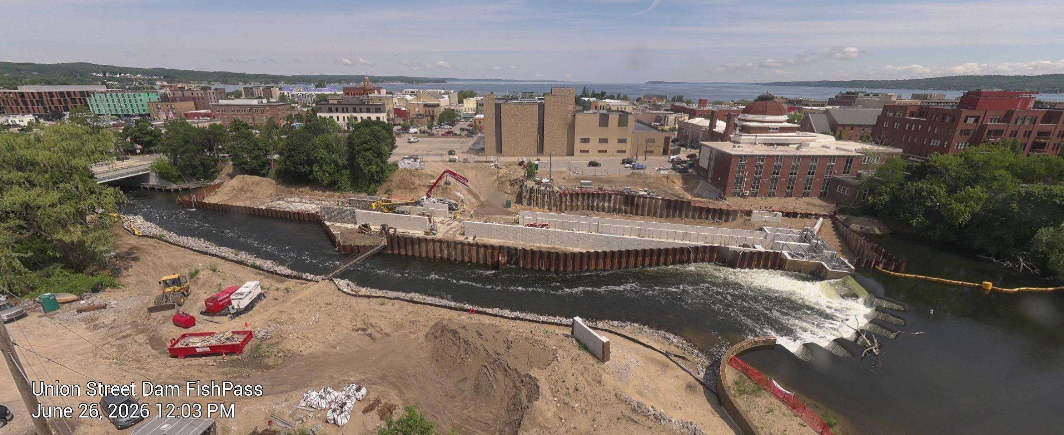
Figure 1. Image capture from the FishPass time-lapse camera: June 26, 2026 showing flow over the new weirs and into a temporary bypass channel, while the contractor continues to construct the fish-sorting channels inside the cofferdam.
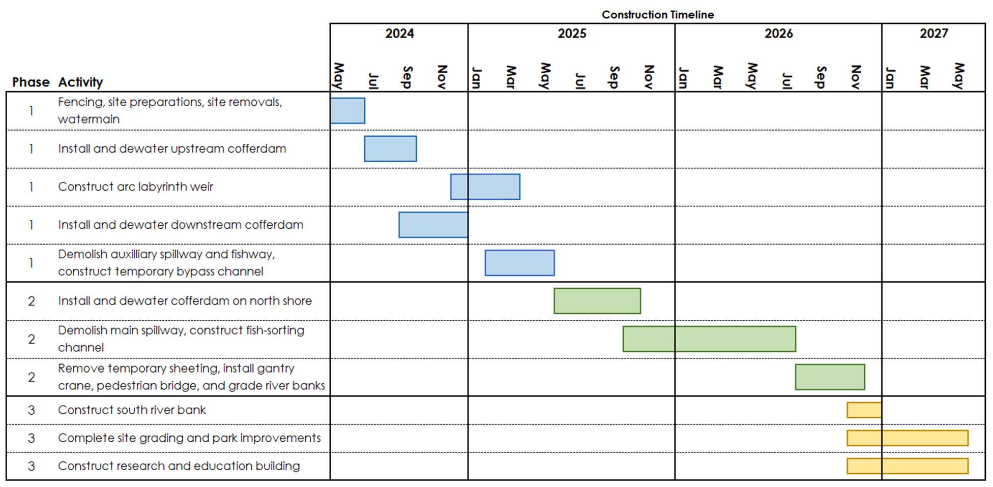
Figure 2. Updated construction schedule for all three Phases of construction. The schedule is subject to change as the project progresses.
- Progress on construction was slowed this spring due to record floods (Figure 3) experienced in April. As had been widely reported, the Boardman/Ottaway River crested around 2,300 cfs (nearly a 500-year flood). During the flooding, crews responded quickly, protecting nearby areas, stabilizing the site, and safely managing flooding within the temporary construction barriers, which ultimately helped reduce the risk of more serious damage. The newly built arc-labyrinth and low-flow weirs performed as designed and prevented what could have been a catastrophic failure under the former Union Street Dam.
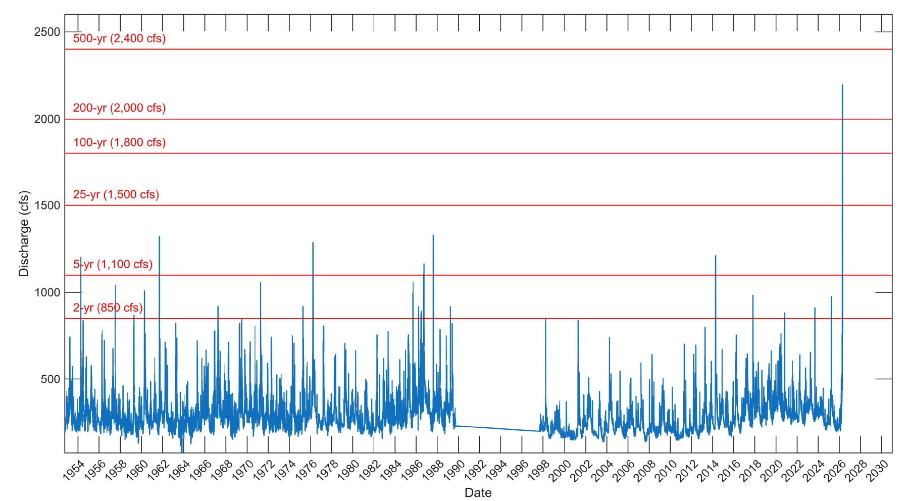
Figure 3. Historic daily average river discharge at Union Street Dam. Data is compiled from historic USGS gauge data and measurements taken at FishPass.
- 09 June 2026 &emdash; The Great Lakes Fishery Commission entered a contract with Spence Brothers (prime contractor on Phases 1 and 2 of FishPass) to complete Phase 3 construction including the upland improvements such as paths, the educational pavilion, and Research and Education Building. The contract for in-stream improvements (Phase 1 and 2) was managed by the U.S. Army Corps of Engineers and is anticipated to be complete by October 2026. The decision to directly contract Phase 3 was based on the on the limited scope of work compared to the heavy in-water construction of Phase 1 and 2 and to reduce costs and improve efficiency. Consequently, involvement of the U.S. Army Corps of Engineers was no longer necessary.
- 15 June 2026 &emdash; The Traverse City Commissioners unanimously voted to approve a Right-of- Entry to the Great Lakes Fishery Commission, and the contractor Spence Brothers to complete Phase 3. An additional Right-of-Entry was required because the original was issued to the U.S. Army Corps of Engineers, which will no longer be involve in management of Phase 3 construction.
Research:
- The GLFC is pleased to welcome Dr. Skye Fissette as the new FishPass Quantitative Research Biologist. Officially starting on 11 May 2026, Dr. Fissette will design and lead studies at FishPass focused on testing and evaluating sorting mechanisms in the fish-sorting channels. Using advanced quantitative statistical techniques, Dr. Fissette will analyze fish behavior and movement data, as well as sorting mechanism efficiency to develop and optimize selective fish passage. Dr. Fissette has a doctorate from Michigan State University in Fisheries and Wildlife and Ecology, Evolution, and Behavior. Prior to joining FishPass, he was a research associate affiliated with the Great Lakes Telemetry Observation System (GLATOS) at Michigan State University, where he investigated fish (e.g., lake sturgeon) behavior using acoustic telemetry data.
- April–June 2026 &emdash; FishPass staff continued operation of a horizontal submerged screen weir (HSSW) at the Michigan Department of Natural Resources (MDNR) Traverse City Salmon Weir (Figure 4 & 5), beginning March 30, 2026. Through the end of June, staff processed more than 19,000 fish. The HSSW is positioned approximately 2 feet above the river bottom at the Salmon Weir to avoid impeding navigation and maintain unrestricted fish passage. The objective of this study is to evaluate the effectiveness of the HSSW for capturing sea lamprey and non-target fishes migrating into the Boardman/Ottaway River. The HSSW will be removed from the river prior to July 2, 2026. Results from the 2026 trap operation are summarized in Table 1.
- April–June 2026 &emdash; FishPass team members conducted eight electrofishing surveys in the lower Boardman/Ottaway River (downstream of Union Street Dam; Figure 5). In collaboration with project partners, FishPass staff have conducted four seasonal electrofishing surveys annually in this river reach for the past six years. The increased sampling effort initiated in 2025 and continued in 2026 is intended to further characterize changes in spring fish community composition and increase the number of tagged fish available for evaluation when FishPass becomes operational. During 2026 sampling, staff implanted more than 500 passive integrated transponder (PIT) tags in fish of appropriate size and condition expected to encounter the FishPass facility in future years. This brings the total number of PIT-tagged fish within the system to more than 4,000 individuals. These tagged fish will support future evaluations of FishPass sorting performance and technology effectiveness. Additional survey results are summarized in Table 1.
- Similar to the issues faced during construction, GLFC staff also encountered challenging operating conditions during both trap operations and fish surveys due to the April flood. High flows contributed to sediment accumulation on the HSSW, reducing sea lamprey capture efficiency relative to 2025. GLFC staff greatly appreciate the assistance of project partners at the City of Traverse City and Michigan Department of Natural Resources (MDNR) in addressing flood-related challenges, including debris and tree removal at the MDNR weir where HSSW operations occurred.
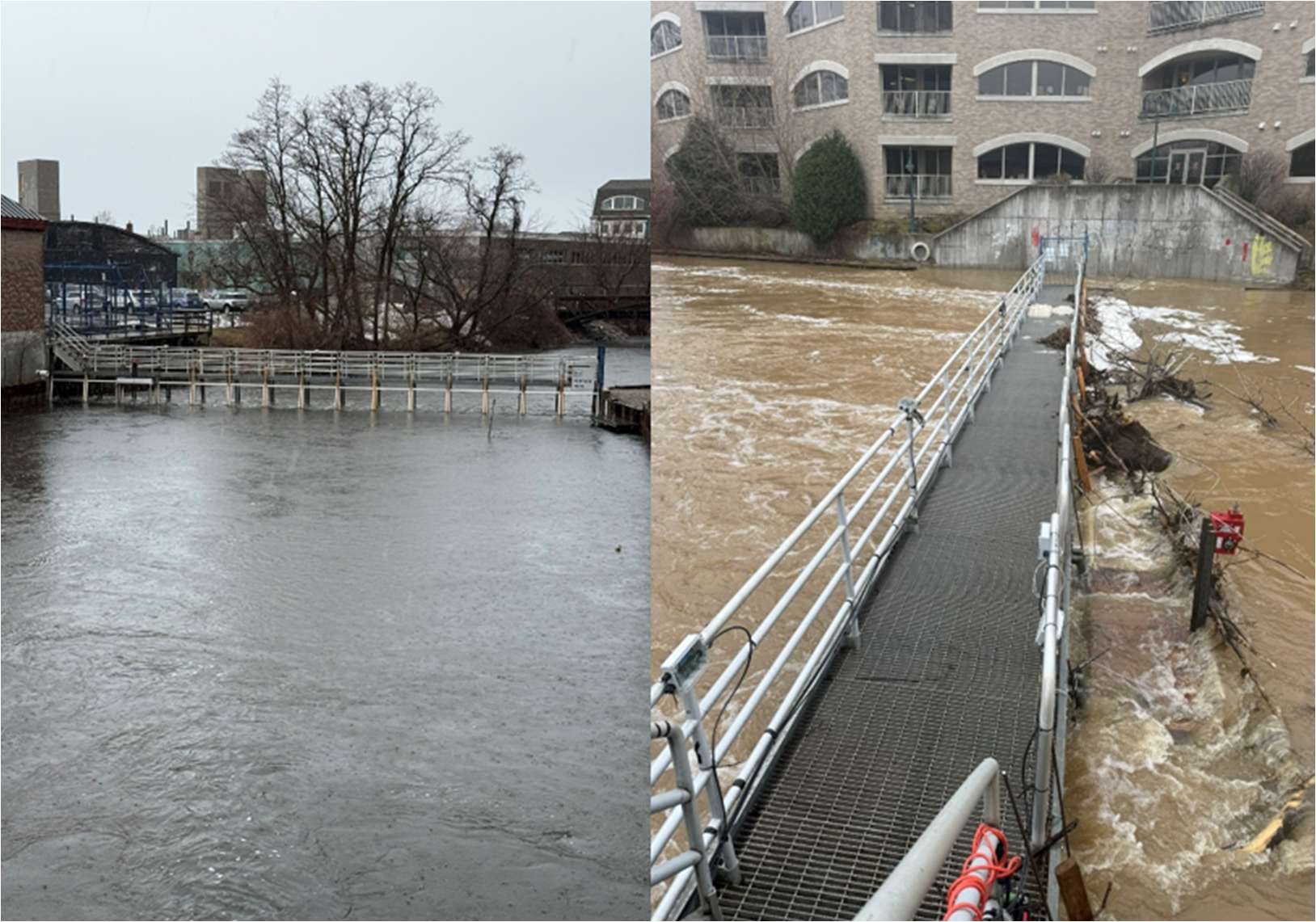
Figure 4. Left: Horizontal submerged screen weir (HSSW) at the MI DNR Traverse City Salmon Weir on 02 April 2026. Right: The HSSW on 15 April 2026 during record flow event.
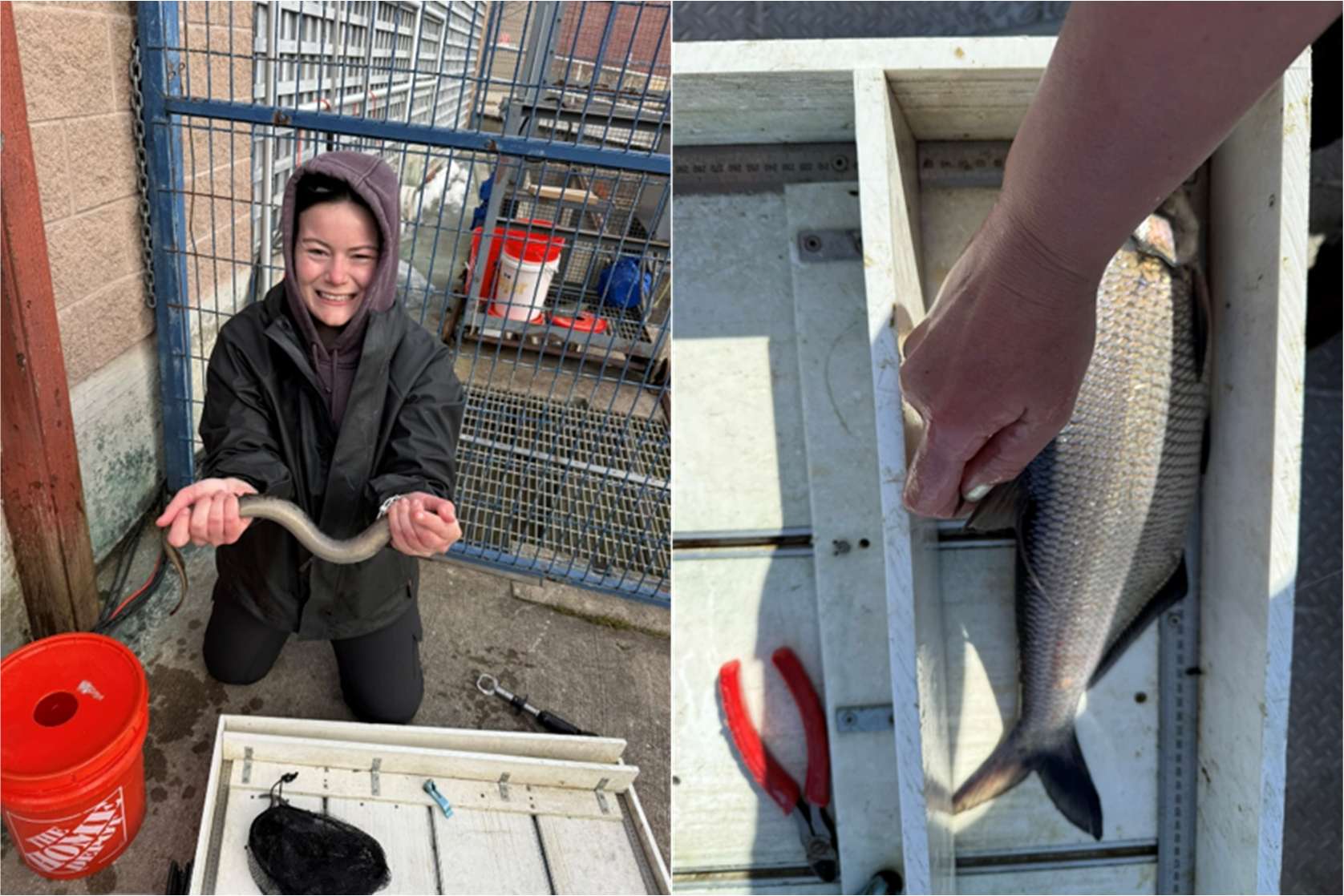
Figure 5. Left: GLFC Fisheries Technician, Abbie Carstens, holding the first sea lamprey Petromyzon marinus capture of the season in the Horizontal Submerged Screen Weir (HSSW) on 01 April 2026. Right: Measurements being taken on a quillback Carpiodes Cyprinus captured during an electrofishing on 05 May 2026; a rare catch in the lower Boardman/Ottaway River.
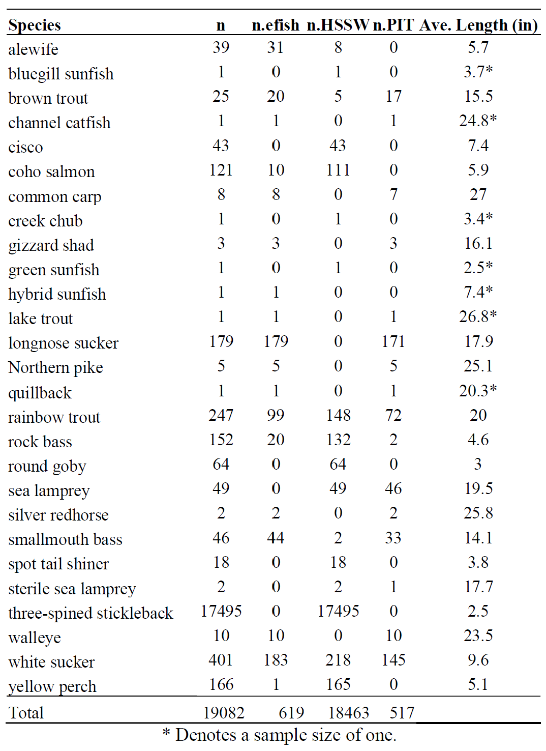
Table 1. The number of fishes (n) sampled in spring of 2026 in the lower Boardman/Ottaway River (i.e., Below Union Street Dam), the number sampled during eight electrofishing surveys (n.efish) on 01, 05, 13, 21, 27 May and 10, 17,23 June 2026 and the number of fish sampled at the Horizontal Submerged Screen Weir Trap (n.HSSW), the number of passive integrated transponder tags implanted (n.PIT), and the average length of individuals measured and during all sampling events.
Outreach and Community Engagement:
- Traverse City Dam Safety Tour and Roundtable with EGLE
- Goodwill Northern Michigan leadership team presentation and tour
- Compass Montessori presentation
- Northwest Michigan Fishing Club Annual Banquet presentation
- Central Michigan University Biology/Education staff engagement
- 2 Live WTCM Jack O’Malley Radio Show FishPass updates
- Fresh Coast Film Festival Sponsorship, Ottaway – River Reconnected screening, and FishPass tour
- Alliance for the Great Lakes panel presentation
- 3 Public Tours
- Presentation to over 100 TCAPs 5th graders
- Tour and presentation to over 300 TCAPS 8th graders
- EGLE Freshwater Drinking Conference tour
- World Fish Migration Day Boardman/Ottaway River Clean Up Event
- Grand Valley State University Tour
- Senator Elissa Slotkin FishPass visit
- Grand Traverse Conservation District Ottaway Crossing Ribbon Cutting
- Citizen science sucker monitoring program in collaboration with the Shedd Aquarium – Special Thanks to volunteers from: NMC, Rotary, Compass Montessori, Greenspire School, Newcomers Club, and the community at large!
Upcoming:
- FishPass Public Tours July 16, August 13, September 24 and October 15
- Fishes of the Great Lakes Public Sails with Inland Seas Education Association
In the News:
- Coverage Themes
- April: Historic flooding and FishPass resilience.
- May: Community engagement and public education.
- June: Final construction phase and project progress.
- Coverage
- April 15, 2026 — 9&10 News Traverse City FishPass project flooded but not damaged, officials say
- April 25, 2026 — Northern Express FishPass Flood Heroes
- May 2, 2026 — Traverse City Tourism Water/Ways Film Event & FishPass Tour
- June 10, 2026 — WCMU Public Media Damage limited in record-breaking flood by 'someday' investment
- June 17, 2026 — 9&10 News FishPass Project in Traverse City Enters Final Construction Phase
- June 18, 2026 — Stormwater Solutions Infrastructure investments averted major environmental incident during record flooding
- June 22, 2026 — Spectrum News FishPass nears finish line on Boardman-Ottaway River
Previous Updates
- Apr-June, 2026
- Aug-Sept, 2025
- June-Aug, 2025
- Apr-May, 2025
- Feb-Mar, 2025
- November, 2024
- October, 2024
- September, 2024
- August, 2024
- Third Quarter 2024
- Second Quarter 2024
- First Quarter 2024
- Fourth Quarter 2023
- First Quarter 2023
- Fourth Quarter 2022
- Summer 2022
- Spring 2022
- Sept, 2021
- June, 2021
- May, 2021
- Apr, 2021
- Mar, 2021
- Dec, 2020 - Feb, 2021
- Nov, 2020
- Oct- Sept, 2020
- Aug, 2020
- July, 2020
- June, 2020
- May, 2020